The internal scaling of pollution and congestion of European cities
2 presentations by Yufei Wei and by Estelle Mennicken
When? 18th June 2021, 14:00-16:00
Where? Webex
The Quadtrees Hubs are to share opinions and discuss research in progress. The meetings of Quadtrees Hubs are open to anyone interested and somehow familiar with some quantitative techniques and willing to progress with these. Please contact Isabelle Pigeron-Piroth isabelle.piroth@uni.lu for more information and obtaining the webex link.
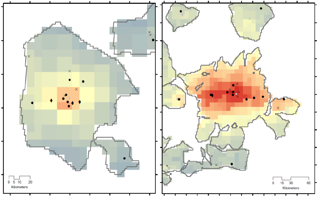
The Effects of Distance to City Centers and Population Size on the NO2 Concentrations in Europe
Yufei Wei (University of Luxembourg, DGEO)
Ground-level NO2 surface concentrations measured by monitoring stations and tropospheric NO2 columns from Sentinel-5P are the data sources of NO2. We filter the data to get the annual mean NO2 concentrations of European cities. We regress the data to find how urban population size influences the NO2 concentrations, and how the NO2 concentrations change within the cities.
The results show larger cities have higher levels of NO2 concentrations. We also find distinct spatial patterns of the NO2 concentrations within the cities. The results indicate monitoring stations and Sentinel-5P are reliable in describing and predicting the NO2 concentrations of European cities.
European urban cores under pressure: quantifying the congestion of trips in and out from city centers as function of population size
Estelle Mennicken (LISER, UDM)
Traffic congestion has many negative social, environmental and economic consequences. We can cite among others the loss of time (hours of delay) inducing productivity and well-being losses, the excess fuel consumption, and the excess emitted CO2. Understanding and quantifying this phenomenon at the scale of an entire continent is therefore a serious societal challenge. In particular, we focus on comparing the accessibility of city centers based on the geographical location of urban areas but also on the population size. Larger cities benefit from positive agglomeration effects but whether they proportionally show more radial traffic congestion is still an open question.
We simulate intra-urban trips between residential locations and city centers in 303 European cities and retrieve travel information around the clock during a typical weekday. We then compute several congestion indices to reveal the excess time people spend on roads driving during peak traffic time compared to a free-flow situation and establish a city ranking. Second, we observe how the total population size influences the indices. Finally, thanks to previously computed detour indices, we examine the relationship between the physical road network shape and the congestion.